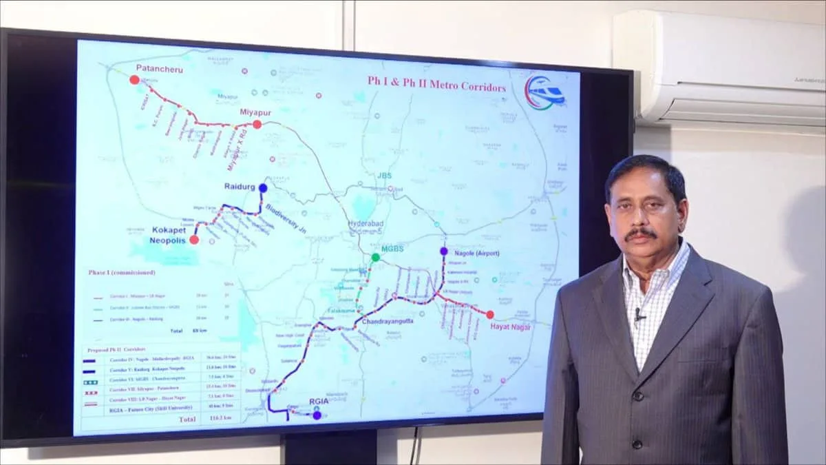
Hyderabad: Final touches are being given to Detailed Project Reports (DPRs) for the Hyderabad Metro Rail’s second phase, comprising six corridors with a total length of 116.2 km and expected to cost Rs 32,237 crore, a top official said on Sunday.
This second phase includes the corridor from the Rajiv Gandhi International Airport (RGIA) to the proposed Fourth City, which is estimated to cost Rs 8,000 crore. The project is proposed to be implemented as a joint venture of the Telangana and the Central governments, like most other Metro Rail projects in other Indian cities, said Hyderabad Airport Metro Ltd (HAML) Managing Director N.V.S. Reddy.
He has informed chief minister A. Revanth Reddy that DPRs for all the corridors are being given final touches and that HAML is awaiting the traffic study report of the Comprehensive Mobility Plan (CMP) being prepared for the Hyderabad Metropolitan Area by the Hyderabad Metropolitan Development Authority (HMDA).
The traffic projections for Metro corridors have to be cross-checked with CMP, as a mandatory requirement for submission of DPRs for the Centre’s approvals, he said.
Cyberabad police book 17 pubs in Hyderabad for noise pollution
DPRs for all these corridors will be finalised in the next few weeks for approval of the state government and for forwarding them for the Centre’s approval.
The Airport Metro alignment is now being finalised via Aramghar and the New High Court location on National Highway 44 (Bengaluru Highway) to reach Shamshabad Airport.
After in-depth discussions, the chief minister approved the broad contours of Metro Phase II corridors.
Metro Phase II Corridors:
Corridor IV will be the Airport Metro Corridor from Nagole-RGIA for 36.6 km. It will pass through L.B Nagar, Karmanghat, Owaisi Hospital, DRDO, Chandrayangutta, Mailardevpally, Aramghar, New High Court, and Shamshabad Junction on the National Highway. This Airport line will be connected to all the existing Metro lines at Nagole, L.B Nagar, and Chandrayangutta respectively. Out of the total length of 36.6 km, 35 km is elevated and 1.6 km is underground, with 24 metro stations including one underground station which is the Airport station.
Corridor V will cover 11.6 km and will be built as an extension of the Blue Line from Raidurg Metro station to Kokapet Neopolis via Biodiversity Jn, Khajaguda Road, Nanakramguda Junction, Wipro Circle, Financial District, and Kokapet Neopolis. This will be a wholly elevated corridor with 8 stations.
The second phase also includes connectivity to the Old City. Corridor VI or Old City Corridor from MGBS to Chandrayangutta will be 7.5 km long.
N.V.S. Reddy said that this corridor is being built as an extension of the Green Line from MGBS to Chandrayangutta. This 7.5 km line from MGBS travels via Darulshifa Junction, Mir Alam Mandi Road, Shalibanda Junction, and Falaknuma.
About 1,100 properties are getting affected by the road widening and Metro alignment. Notifications have been already issued for 400 affected properties and the rest are in progress. There are 103 religious, heritage, and other sensitive structures in this route and all of them are being saved through appropriate engineering solutions and adjustment of Metro pillar locations. This is a wholly elevated metro corridor with about 6 stations.
Corridor VII is being built as an extension of the Red Line on the Mumbai highway. Starting from the existing Miyapur Metro station, this 13.4 km line up to Patancheru travels via Alwyn X Road, Madinaguda, Chanda Nagar, BHEL, and ICRISAT. This is a wholly elevated corridor with about 10 stations.
Corridor VIII is being built as an extension of the Red Line from L.B Nagar side on the Vijayawada highway. This 7.1 km corridor from L.B Nagar to Hayat Nagar goes over Chintalkunta, Vanasthalipuram, Auto Nagar and RTC Colony. This wholly elevated corridor will have about 6 stations.
The Corridor IX is planned from the RGIA to the proposed Fourth City near Hyderabad via Mansanpally Road, and the Outer Ring Road (ORR) stretch between Pedda Golconda exit and Raviryal exit. This line will have a length of about 40 km from Shamshabad Airport to the Skill University location in Fourth City. This will have about 2 km of the underground portion within the Airport area, an elevated portion of about 20 km, and an ‘At Grade’ (road level) portion of about 18 km. The ‘At Grade’ portion of 18 km from ORR Raviryal exit to Skill University will be designed as a part of the new green field 300 feet road.