Hyderabad: Telangana IT minister KT Rama Rao’s (KTR) recent threat of cutting water and electricity supply to the Secunderabad Cantonment areas in the state legislative assembly has once again sparked protests in the form of signature campaigns and candlelight marches over the last few days in the Army-controlled areas of Secunderabad
KTR demanded that the public roads closed for various reasons by the military be reopened. The Local Military Authority (LMA), as an extension of the central government, has made the residents of the cantonment area feel like aliens in their own backyards. And one of them has now dug deep into the pits of history to actually find out whether the army is rightfully running the show, or not.
Pankaj Sethi, a researcher focusing on Secunderabad history, in a series of tweets last week, explained the significance of the Secunderabad Cantonment area in the city’s history and explained how it has always been under the control of the state, first by the Nizams of Hyderabad, and later by respective state governments.
After 1947, British-owned lands on which cantonments were set up, were passed over to the Indian government. At that time, Hyderabad was a sovereign princely state; the largest in British India. After independence, the last Nizam of Hyderabad, Mir Osman Ali Khan, was among the handful of states that refused to join India and wanted to stay independent.
His deliberations with the Indian government would not bear fruit, as the Indian army marched into the Hyderabad state on September 17, 1948, and annexed it (it may be noted that the Hyderabad state was also witnessing a parallel movement in the form of a communist-backed peasant rebellion in Telangana from 1946-51, called the Telangana Armed Struggle).
However, the cantonment that was set up in the city continued to be on state-owned land after 1948 as well. And therein, lies the irony of the situation, as it eventually came under the Indian government, or army’s control eventually, in spite of it being owned by the state.
The East India Company’s Treaty of Subsidiary Alliance with the Nizam Asaf Jah II (Nizam Ali Khan, 1762-1803) meant that both parties would provide troops to each other against common enemies. As a result, the area where the British troops were stationed would eventually be known as Secunderabad.
It was founded in 1806, named after the then third Nizam, Sikandar Jah. The Nizam’s troops were placed in the Bolarum area initially. The British convinced the Nizam to let them take charge of the troops and raise a fresh contingent at the state’s expense.
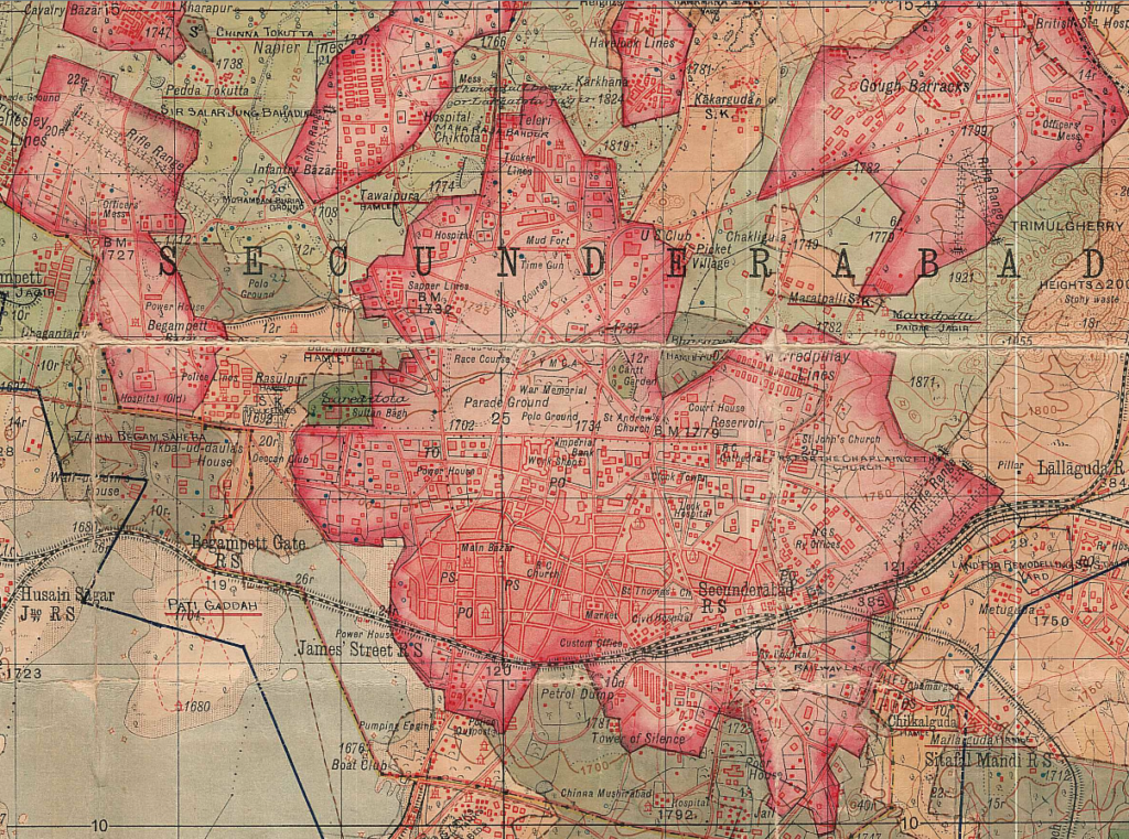
Sethi states, “The crucial point is this: Though Nizam allowed the British to occupy the land for military purposes, he did not give them ownership of that land. We know this through the following evidence available in the National Archives and from other archival records: In 1906, Bolarum, Secunderabad and 13 intervening villages were merged to form the single area now called Secunderabad.”
In 1933 the British prepared the first comprehensive land record of Secunderabad. The Special Lands Officer appointed for preparing this “General Land Register (GLR)” stated that the British did not own any land in Secunderabad.
In the 20th century, the Nizam took back land that was termed Military land- the Chaderghat municipality and the Residency Bazars. In 1946, The town area of Secunderabad was taken back.
A majority of the reclaimed land belonged directly to the Nizam, The rest of the land was privately owned. By 1948, during the annexation of Hyderabad, Maj Gen J.N. Chaudhuri, who led Operation Polo, the military action through which Hyderabad was annexed to India, convinced the Nizam to hand over the land to the State.
By being offered a crore rupees every month along with other concessions, the Nizam agreed.
By the time of Operation Polo in 1948, sarf-e-Khas (Nizam’s private) and jagir (allotted to landowners) lands together accounted for almost 80,000 sq km out of the 2,10,000 sq km total area of Hyderabad. Oppression of peasants by this aristocracy had led to a violent, communist-supported peasants’ revolt a few years earlier. This revolt was still ongoing when the Indian Army entered in 1948.
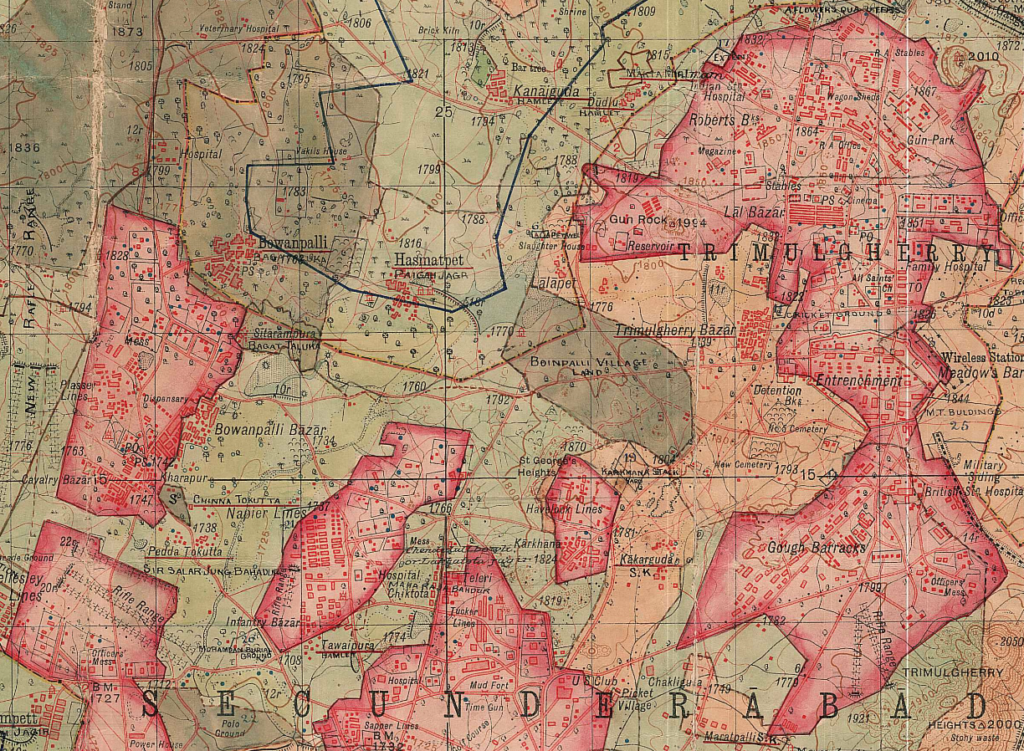
Two Regulations were passed in 1948 to formalise this – “Hyderabad Sarf-e-Khas (Merger) Regulation 1358F” and “Hyderabad (Abolition of Jagirs) Regulation 1358F”. Thus, overnight, 80,000 sq km of land owned by the aristocracy became Diwani, or state land. This was perhaps the largest land reform in independent India.” Importantly, this also meant that the lands which accounted for the entire public land in the cantonment— also became state land.
“Strangely though, a new General Land Register prepared by Govt of India in 1956 (after the merger of Hyderabad with India) shows all public lands in cantonment as belonging to Govt of India!” wrote Sethi.
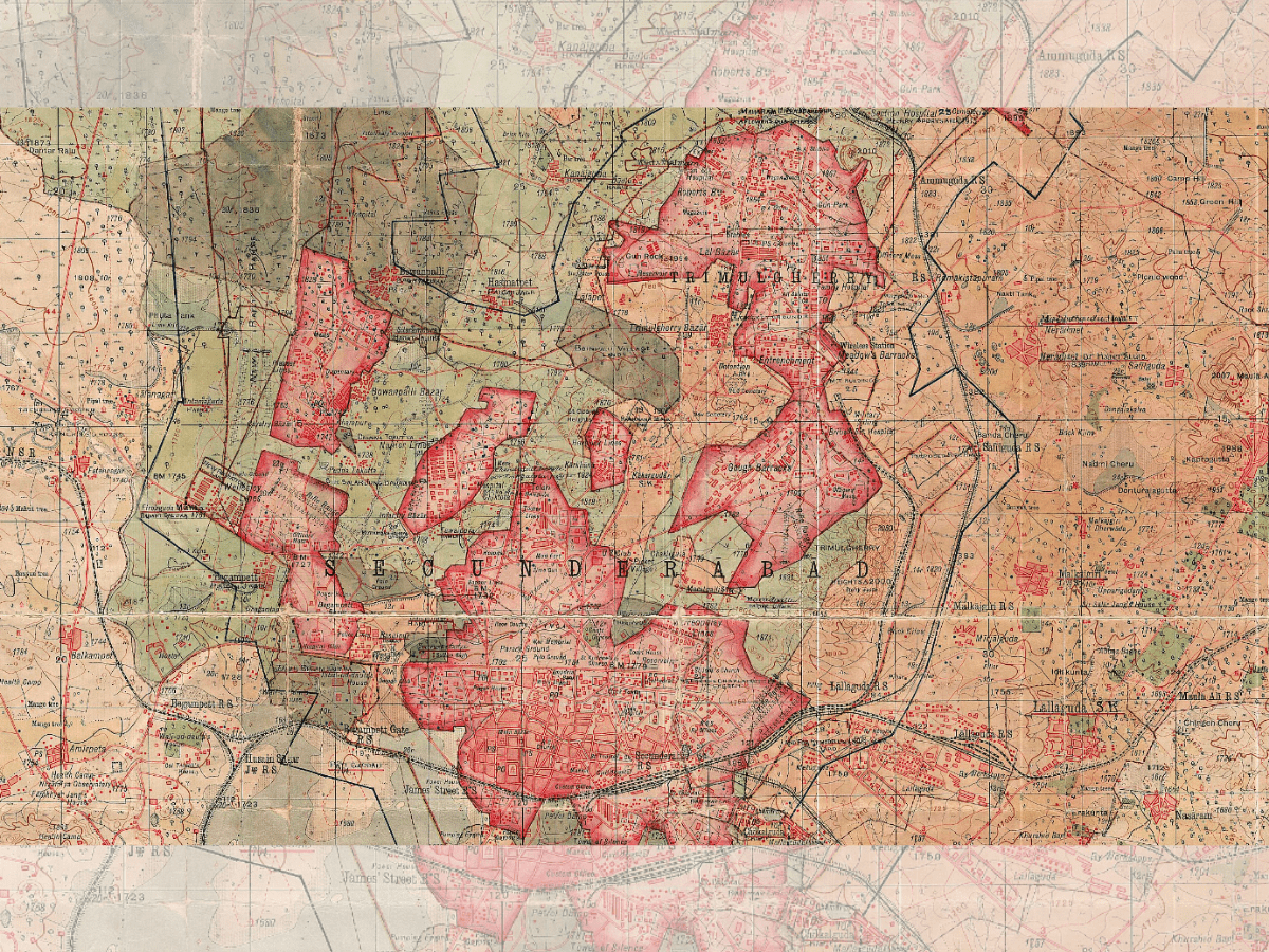
This map from around 1930 shows the boundary of a cantonment (dark black line forming a “J: shaped area from Hakimpet to Husainsagar and west towards Begumpet). Within the boundary, various colours are used to show the type of land. Dark green and light brown are sarf-e-Khas and Khalsa lands – both directly owned by Nizam. Light green is jagir and makta land – indirectly owned by Nizam. The reddish islands are the places which the British were actually occupying – but these were also owned by the original owners. This map is proof that public lands in the cantonment were owned by the Nizam directly or indirectly.
However, the Central Government’s claim of ownership has been rejected on multiple occasions by governments and courts. In 1956 Govt of India actually had to purchase Rashtrapathi Nilayam-the erstwhile Bolarum Residency of the British – from Govt of Andhra Pradesh, showing that the premises were the property of the state government.
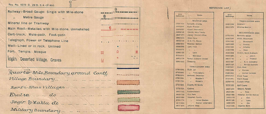
Many individual court cases have successfully challenged the central government’s claim of land ownership in cantonment. There are Resolutions of the Secunderabad Cantonment Board, and even internal reports of the Government of India, which conclude that the Central Government does not own public lands in Secunderabad Cantonment.
“It thus seems clear the reality of ownership of public lands in Secunderabad Cantonment is different from that in other cantonments. The cantonment’s land record needs to be corrected to reflect this,” stated Sethi. Records show that the lands that are today considered to be owned by the centre because of the military presence, are actually the state’s.
This asks the imperative question of how much freedom the LMA actually has on the roads and lands of the cantonment area. The residents of the land under question have hoped to see a change since 2014, but the roads remain unopened even today

